High Point and low points - I loved them both today (Monday, May 7, 2012). High Point State Park, with its impressive obelisk standing on the highest point in New Jersey was the feature of my morning walk.
And then in the afternoon I began the trek along the NJ/NY state line, which included a 0.2 mile board-walk over a swamp on puncheon.
I know I've had a good day when I take lots of photos. Today I took close to 100. Some are duplicates and some don't make the cut, but my final collection of 'keepers' still numbered 44. Most of them you can see at the Every Trail site, linked to below.
As I said good-bye to Kittatinny Mountain, I was leaving the last vestiges of 'Rocksylvania' behind. I was warned that the rocks extended half-way into New Jersey, and the warning was correct. As long as you're on that long ridge system that runs from Cove Mountain south of Duncannon, PA to High Point, NJ, you're going to find significant rocky patches, some pretty long and pretty difficult, or at least they feel that way.
Once I was down in the north Jersey lowlands, the big issue was the muddy patches. But these were short, and there were usually stepping stones to get you through. And the benefits far outweighed the difficulties. It was an ever-varying footpath, passing old rock walls still standing strong, numerous pastures with stiles, and two beautiful ponds. Here's the shot of my favorite - really a magical spot where I wished I could linger for hours:
It started to sprinkle in the afternoon, and by 3:30 it had turned into a steady light rain - enough to get my trail running shoes pretty wet, but otherwise my core kept warm and dry, so my soul was content.
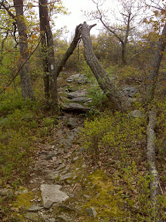
Now one last note - the 'AT logo phantom' struck again today. About a half mile south of the High Point monument I passed under this 'A-frame' blow-down directly over the trail. And I couldn't resist taking a couple minutes to fashion the ultimate hiker-interactive walk-through AT logo. Who knows how long it will last before some ingrate trashes it, but at least I've got photo documentation :-)
--------------------------------------------------
Below is a map with the track of my hike. There's an extraneous straight line connecting two different places where I parked to start hiking the various sections I did today. I don't know how to delete that, but it represents a drive with the GPS turned off. The title line above the map is a link to the site where I've uploaded all the promised photos.
AT Day 117 - High Point, NJ at EveryTrail
EveryTrail - Find the best Hiking in High Point State Park


No comments:
Post a Comment