Wednesday, August 29, 2018

Five Killer Hikes - Big Island sights most people never see


The arch shown above is the best free standing sea arch on the Big Island, yet there's no trail here, no signs, no markers, no name, as far as I know.  It's so remote that you have to hike three miles over the rugged 1859 lava field to get here from either the north or the south.  Even people who pass by here often miss seeing the arch.  This a future part of the Ala Kahakai National Historic Trail--hike number One for this report.  Someday this arch will be famous, but for now, it's a secret gem.


Hike Two was along a straight, little used Jeep Track that runs about 8 miles through Upper Waiakea Forest Reserve between Saddle Road and Stainback Highway at about the 4300 foot elevation.  It's called simply 'Tree Planting Road'.  Locals know about it--especially hunters.  I found it by just stopping in the right place to take a look at the track that shows up on the satellite view.  It was a cloudy damp day with the remnants of Hurricane Lane still plaguing the island.


Hike Three took me up to the cool flanks of Mauna Kea at 9000 feet and about a mile off the summit access road.  Another 1000 feet up and there's no vegetation, but here the grasses and mamane trees are making a stark statement.  The same misty day.  Mauna Kea Access road was still closed by washouts.


Hike Four took me inland across the 1859 Lava Flow, on the Ala Loa - the King's Road, a 32-mile 19th century horse/mule commerce route between Kailua Kona and the harbor at Kawaihae.  Almost nobody hikes this part of the old trail.  These marker cairns were carefully placed every 25 feet or so 150 years ago.  Note the trail winding away slightly to the right before disappearing over the horizon.


Finally Hike Five is my favorite, and this is my third visit, second this trip.  It has amazing diversity, and just about the right hiking temperature, being just below 6000 feet elevation on the upper slopes of the windward side of the Saddle.  Last time I hiked the Pu'u 'O'o Trail it rained the whole time.  Today there was just a glorious coating of dew on everything.


Other sights along the Pu'u 'O'o Trail:

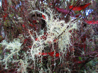
Lichen, perked up by all the recent rain
Berries in a quiet savanna meadow
A little pond, usually just a dry depression, more lichen, and more peaceful meadow
Yet another variety of lichen, this one deep in a forest understory
Natural art of the forest over-story
A shallow cave, collapsed lava tube

And Hike One also featured a variety of great sights:

A hike-through natural lava arch with a low ceiling and killer view of Kiholo Bay
Another look at Kiholo Bay.  This is what's left of a massive fish pond built by Kamehameha I and destroyed by the 1859 lava flow.
Wow!  Rainbow lava.
Keawaiki Bay and Beach
Two more remote, seldom seen sea arches side by side.

Here are the GPS Tracks for these remarkable hikes:

Hikes One and Four.  I made a loop out of them.
Hike two with a false start down another interesting jeep track
Hike Three, based at the Mauna Kea Visitor Center, which was closed.
And finally the Pu'u 'O'o Trail redux, hike five.

What's next.  Whatever it is, chances are there will be some stunning sights.

Thursday, August 23, 2018

Hiking the Oldest Nationally designated trail in the USA


The Ala Kahakai National Historic Trail is among the newest additions to the National Trails System (legislation passed November 13, 2000), yet as a trail it is centuries older than any of the other trails in the system.

These surf-smoothed paving stones were probably set in place long before Columbus reached the New World.


They say the name means "Trail by the Shoreline".  In places it is called the Fisherman's Trail, and its symbol is the ancient native (usually bone) fishhook.


The trail is 175 miles long, covering the entire western shore of the Big Island and the greater part of its southeastern coastline.  It is Hawaii's major contribution to the National Trails System and therefore the state's designated "Heart of" segment of the nationwide Fifty Trail.


It crosses government land, private land, and Traditional Homeland property.  The reaction of the descendants of the trail builders themselves--the original stewards of the land--is a puzzle I'm working hard to unravel as I consider living here.  And it's way too complicated to go into in this post.  But a comprehensive trail planning document says that the Department of Hawaiian Home Lands, who administers 200,000+ acres, and redistributes some of these lands to people of at least 50% native blood, is "in general, not supportive of public access" to these ancient trails.  Yet in my experience these homeland tracts are among the most abused lands, often riddled with a maze of ad-hoc jeep tracks.  See my previous report on the Green Sand Beach and South Point for one example.

Anyhow, this report covers the least problematic part of the trail, and its current epicenter, about seven miles in length, which is well-blazed and open for business.


Many more pieces of the trail are open for hiking, and I've already reported on a bunch of those.  But here we have trail that has uniform signs at every turn and access point.  Not only is it a Nationally recognized trail, but it is part of the State of Hawaii's official trail system called 'Na Ala Hele' (meaning simply walking paths).  That's their symbol at the top of the sign.

This part of the trail passes in front of two major ultra-luxury resorts, the Mauna Kea Beach Hotel, and the Westin Hapuna Beach Resort.

Here's the Mauna Kea and its beach.


Hapuna Beach regularly shows up on lists of the world's best beaches.


Yet there are sections with wonderful solitude, such as the little beach shown in the headline photo above, south of Spencer County Beach, and undeveloped Mau'umae Beach, shown below.


Along the way there is opportunity to visit with native and non-native wildlife.  This is the 'iole manakuke, Hawaii's answer to the squirrel, though this is no native.  It's a badly invasive mongoose from Asia.


At Hapuna Beach they have a gaggle of resident nenes.


And in quiet shady areas you'll nearly always run into resting sea turtles.


The historic trail lives up to its name, passing sacred sites such as the Pu'ukohola Heiau National Historic Landmark where Kamehameha I consolidated his power.


Replica twin hulled canoe and outriggers can be seen plying the waters just offshore.


The coral stone cairns are most likely the work of tourists.


And finally the shores are replete with many of my favorite subjects--the specimen trees of all shapes and configurations

This last one is an import from Madagascar - the Royal Poinciana

Here's an interactive map of the parts of the Ala Kahakai Trail that I've hiked that are part of this core section in South Kohala and adjacent North Kona districts.


Powered by Wikiloc

You can zoom in as closely as you wish to have a look at the amazing variety of beaches, resorts, sea cliffs, historic landmarks, and miscellaneous stuff to be seen along this amazing trail.

The two southern legs of trail shown on the map were covered in an earlier post.  As of the date of this publication there were more miles of trail continuing south from there that I intended to hike.  They'll show up on the above map after I've done them.

All of it adds up to, in my estimation, a true bucket list trail destination.  Hope you can get out here and see for yourself.

Friday, August 17, 2018

The Green Sand Beach and more Polynesian Footprints


This is a report of my two-day tour of the best hikes on the south end of the Big Island of Hawai'i - the Ka'u District.  The obligatory visit was to one of only four green sand beaches in the world.

Papakolea Green Sand Beach is legally reached only by hiking three miles.  But the no-drive restrictions are clearly not enforced.  I think this has to do with the fact that all the land here is part of a 10,000 acre parcel owned by the Hawaiian Homelands Trust, and that there seems to be a problem of 'buck passing' on these lands.  One look at the erosion explains why driving here is not a good idea. 


The beach gets its distinctive color from little semi-precious gem stones, olivine, embedded in the lava that erupted in this area.


Here's a wider view of the beach.  It is set inside a cinder cone that erupted the olivine-rich lava right at sea level.


Yet the greenest sand is not here.  The famous green sand beach has impurities of black sand and white coral sand.  I found a coastal area about a mile and a quarter away that didn't have a lot of green sand but what it had was stupendously green, and contrasted starkly with the black lava, the red earth, and the blue sea.


I also visited the famous Punalu'u Black Sand Beach.  Meh. 


First of all, black sand beaches come by the dozens on the big island.  And I've seen many better ones.  This one got popularized, but I do not understand why.  Most of the shore is actually rock.  The sandy swimming area is tiny.

I was really there to visit the best example I've yet seen of the ancient Polynesian trail building art - a centuries-old trail paved with smooth foot-sized stones through jagged 'a'a' lava about a half mile east of the beach


I can't seem to get enough of these old trails.  Here's another well-preserved segment.


Nowhere that I know of except the Inca trails in South America, does such an extensive network of ancient footpaths survive to be hiked today.

I also visited the southern-most point on the island, and thus the southern-most point in the United States, and found another great example of ancient Polynesian stone-craft


In between South Point and the Green Sand beach I visited the plastic sand beach.


The southern tip of the island seems to intercept floating plastic debris from all over the tropical Pacific.


Inland I went up to Manuka State Park and hiked their nature trail.  It's a two mile trail in a pretty forest, but the area was suffering serious drought.  Many of the understory plants were wilting and most everything else was dropping leaves.


I finally did get a photo I've been hoping to get - of one of the most colorful denizens of the island.


He's not a native.  This is probably a gold-dust day-gecko, originally from Madagascar.

Finally I went up to the Kahuka Unit of Volcano National Park--the only unit that is currently open to the public--and hiked the only decent trail they have open.  This part of the park was recently acquired and was formerly a big cattle ranch.  The savanna-like setting is gorgeous, and I've not seen so many huge specimen ohia trees before.  But it is an artificial landscape--purely a result of cattle grazing, preventing young trees from growing.


Before Europeans arrived, this area was a thick forest, and I presume that's the way it will eventually become again now that the land is protected.

Although this area is only ten miles from Manuka, it showed no signs of drought, and a few of the Ohia trees were resplendent with bloom. 


This has long been my favorite Hawaiian native tree, but the park rangers told me about a new threat - Rapid Ohia Death.  The rangers didn't even know what causes it, though the web site in the link points to two related fungus species that humans can spread--apparently via something as innocuous as the dust on the undercarriage of their vehicles.

At this point they don't even know where this fungus came from.  But it didn't show up and start killing Ohia until a few years ago.

From what I could tell, healthy trees may not be threatened - at least yet.  Let's hope this isn't such a devastating killer like the American Chestnut Blight, Dutch Elm Disease, or Emerald Ash Borer.  I couldn't bear to see another great iconic regional tree disappear from the landscape.