Showing posts with label North Country Trail. Show all posts

Saturday, October 7, 2017

Hiking The Iron Belle Trail into Wisconsin

 
Until a couple weeks ago, I had not heard of the Iron Belle Trail.  Surprising, since it is 1273 miles long and I've already hiked most of it.  It is Michigan's official state trail, extending the length of the state from Belle Isle in Detroit to Ironwood at the west end of the Upper Peninsula.  The reason I'd not heard of it is that the idea of an official state trail for Michigan is very new.  The name was just announced in 2015.

It is here in Ironwood where I finally saw the 'flesh-and-blood' manifestation of trail by that name.  Here it's a brand new paved bike trail--less than a year old and so new it doesn't (as of the time of this writing) even show up on the Google Map satellite view.  Here is the proof of that--a close up of the Google Map view of the Siemens Truss Bridge and a beaver pond, and then the 'ground truth'.  The image is copyright 2017 - I estimate it was captured in late 2016 or early 2017 based on the deciduous trees being bare of leaves.


This bike trail into Ironwood is *not* part of the North Country Trail, but the vast majority of the designated hiking route of the Iron Belle trail is indeed coincident with the NCT, so, as I said, I've been hiking it for months without knowing it.  I was even hiking it (the separate bike route) when I deviated from the NCT to hike the North Central Trail in northern Lower Michigan.

It was a frosty morning when I hiked this converted rail bed into Ironwood.


Before hitting the new rail trail, I had to finish a road walk past Powderhorn Ski Area.


On the other end, heading into Ironwood, the trail passes the Stormy Kromer Hat factory with its giant ball cap advertising.  I would make this my hat number 92 if only the things weren't so expensive - $45 a pop.


Then near the end, in downtown Ironwood, the trail passes the old train depot building, now an information center with displays honoring iron mining and the lumber industry.


And then, at mile zero,


I crossed into Wisconsin--the twenty-third US state or district (Columbia) that my footprints have connected.


The old railroad bridge in the shot above is the route of the 'Corridor 17' trail.  This is an ATV and Snowmobile trail.  Other motor vehicles are prohibited and hikers are most welcome.


I had zero road walking to get to it. It literally passes right by the bridge from Michigan that the Iron Belle Trail uses, and it will start me south into Wisconsin toward the Ice Age National Scenic Trail and on to my next destination--my birthplace at Madison General Hospital.

Here's the composite GPS track of my departure from Michigan via the Iron Belle Trail and my start into Wisconsin.


I've fashioned a route through Wisconsin that covers a half dozen of the state's major trails and is rich in personal and family history.  Beside my birthplace and my first residence, I'll pass the farmstead of my Great Great Grandfather, who immigrated to Wisconsin in 1852 and lived to be 101 years old.  I'll visit the homes of both sets of grandparents, just two doors apart; and hopefully I'll walk by some of my father's boyhood homes.  Most of that will probably happen next hiking season.  But before this year is over I'll be visiting the Wisconsin north woods lake that was our family's regular vacation spot all through my childhood--a place full of powerful memories for me.  That's just 50 or 60 miles away now.  Stay tuned.

Wednesday, October 4, 2017

The Waterfall Tour


This is it.  I came out of the woods today and won't go back on dirt trail for the rest of Michigan.  Of course the rest of Michigan is only a couple more days now.

The last trail in the woods covered two big rivers and a sorry bit of trail connecting them.  I won't go into that because it appears a reroute is under active development.  I'll focus on the walks beside the Presque Isle and Black Rivers.  Here are the GPS Tracks.


Waterfalls abounded.  Most of them happened where the rivers were carving their way through unusual conglomerate rock made of large rounded stones cemented together with silt and sand and time and heat.  Here's Hat number 89 with my walking stick and my hiking Crocs lounging on a fine example of that lumpy conglomerate.


And here's Hat number 90 on the same sort of material at Rainbow Falls on the Presque Isle River.


Not only is this the last of the woods trail in Michigan, but this is the last photo documenting my hat collection. (I can just about hear the sighs of relief.)

The waterfall collection continued, though, on the Black River.  The headline photo featured Potawatomie Falls.  Though it was not as photogenic on this dim cloudy day, Gorge Falls had by far the most gravitas, with its thundering sound and rising mists.


There were several others, but that is enough tumbling water for one post, and then I was out of the woods.

The road walk took me past Copper Peak's chairlift and ski jump hill.


They don't have any other ski slopes there, just the jump.  But they do have a network of nicely maintained bike trails that I suggest the NCT ought to consider using.


Connect points 3 and 4 and you'd have another nice 1.8 miles of trail in the woods.

From there, as you can see from the third of the GPS tracks, I hiked on south to Powderhorn Ski area.  From there I'm following the route of the Iron Belle Trail and deviating from the published map road walk of the North Country Trail.  I didn't even know the Iron Belle Trail existed until a couple weeks ago, but it turns out that I had been hiking it most of my way across Michigan.  It is Michigan's state trail.  It has a biking route and a separate hiking route.  It partners with the North Country Trail for the hiking route except at either end of the state.  It starts at Belle Isle in the Detroit River and it ends on a wonderful, brand-new paved bike trail that the official hiking route uses from near Powderhorn to the Wisconsin State Line in Ironwood.  More about this in my next report.

Sunday, October 1, 2017

Porcupine Mountains Wilderness - a backpacker's Mecca

This first class hiking trail, featuring miles of panoramic views, is not part of the North Country Trail.  It should be.

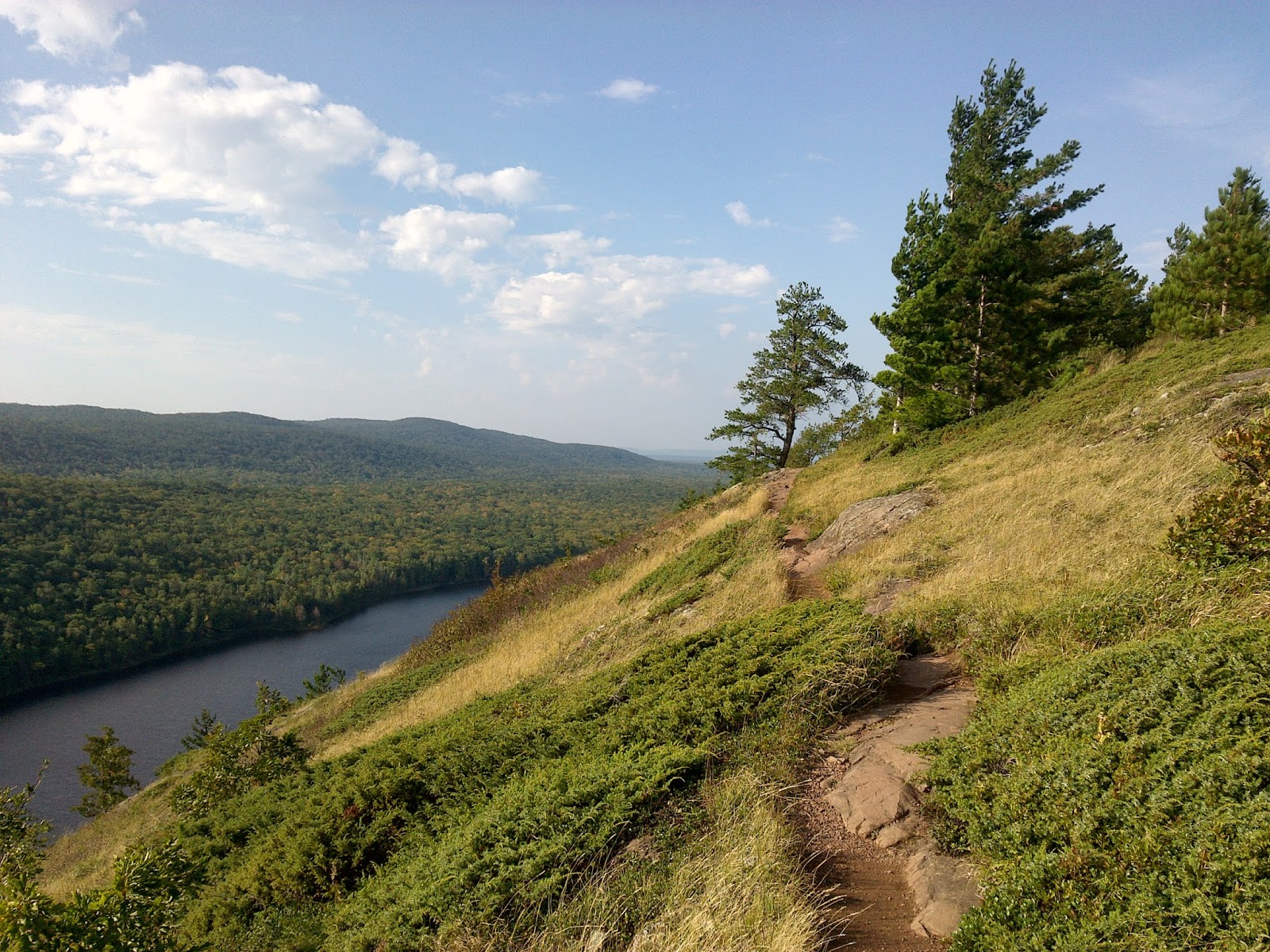
With 91 miles of well maintained trail and some of the best scenery this side of Pictured Rocks, Michigan's Porcupine Mountains Wilderness State Park deserves to be showcased.  There are plans on paper for the North Country Trail to someday be rerouted to take in the best of the Park, including the view shown above, but right now the trail skips along the south edge of the park, missing all of the mountains and views of Lake Superior like this:


I couldn't pass up the opportunity to absorb all this beauty, so I fashioned my own hike through the park.  Here's the overview map of what I hiked and where it deviated from the NCT.


The Escarpment Trail, with its breathtaking views overlooking Lake of the Clouds, is the highlight of the park.  That's where the headline photo was taken.  This is trail worthy of the Gods.  Here is a sampling of more of the spectacular vistas.


There was also this elevated glimpse of the Lake Superior Shoreline off to the east.


And the same four miles of trail also passed a rock outcrop that I'm calling Michigan's "Old Lady of the Mountains".


The ridge of exposed bedrock that allows all these views is glacier-smoothed solid bedrock.  Here Hat 87 and my walking stick highlight some glacier scratches, the signature of moving stones embedded in the glacier being scraped against the bedrock.


The scratches are from lower left to upper right, whereas the natural grain of the rock itself is oriented right to left here.

Off the escarpment there was some good gnarly trail.  This blaze seems to forewarn of the many climbs, up and down the banks of the river gorges and of course the mountains themselves.


Getting down to the rivers meant several miles along the wonderfully noisy Big Carp River on the trail of the same name.


Along the Government Peak trail is another couple miles beside a frisky mountain stream with dozens of cascades, Trap Falls being the only named one.


The other end of Government Peak Trail brought me to picturesque Mirror Lake


Note that not one of the photos above is taken along the route of the North Country Trail.  Hats 88 and 91 did find poses along the route of that trail.  Number 88 found a hat-sized mushroom.


And with the maple leaves dropping, Hat 91, sporting the colors of my Dad's Alma Mater, found itself in its natural element.  Can you find it in this scene?


This park is truly special--a place truly worth preserving in its natural state.


It all lies in primary forest, full of huge trees and not touched by loggers in ages; and the DNR has built a number of rustic cottages that are for rent, as are dozens of prepared primitive campsites with fire pits and bear poles.  It's the only place in Michigan that I've met backpackers out doing multi-day hikes, taking advantage of all this infrastructure.  It was so much fun to talk trail and not be talking to myself for a change.

Thursday, September 28, 2017

Trap Hills and beyond - a dozen wilderness viewpoints


Michigan's western Upper Peninsula - the region west of Marquette - has won my heart.  There's something about the ecology of the forests, the soil, the climate, and especially the remoteness, that makes for a primal hiking experience.  Some might fear getting lost here.  The trail is, in places, barely a trace.  But for me it is a place where I feel 'found' - where I am most at home.

It's not something that always lends itself to photography.  How do you photograph a sense of peace and quiet?  How do you document the wonderful *lack* of signs of human disturbance?  How do you convey the sense of being in a great natural cathedral?

The trail has begun to take me through vast stands of primary forest now, after all the logging and trashy young regenerating areas I complained about in a previous report.  Here, even where the land is flat for mile after mile the understory is open, giving you a sense of the grand scale of the woods.  This is especially true in the seemingly endless stands of sugar maple with red maple in the wetter areas, and the dark thickets of giant hemlock with boles so massive that you can't stretch your arms halfway around them.  The transitions between these basic forest types come mixed with spruce and balsam fir, the occasional white pine, and stands of bigtooth and quaking aspen, paper and yellow birch.  Where you find northern white cedar the footing can be rooty and boggy, but the trail builders have tended to avoid these areas where possible.

Where the roots of the earth itself rise up, having resisted the long millennia of grinding of the glaciers, the bedrock lifts skyward in great rounded mounds, called Monadnocks in New England.  There I have something to photograph and share.  And there is where the trail has been taking me whenever possible lately.

Hat number 85 sits on a sloping ridge of the bare, glacier-smoothed bedrock, overlooking the wild landscape.


Rarely can you detect signs of human presence below.  It compares favorably with Maine's hundred mile wilderness along the Appalachian Trail.

If you look closely, you can spot a bit of Lake Gogebic in this view--near the horizon, just left of center.  Most of its 14-mile length is hidden behind higher ground farther to the left, but Lake Gogebic is the largest natural 'inland' lake in the Upper Peninsula.

It's going to be tough to leave this area.  I'm getting spoiled by constant 'real trail' without interruption.  Hat 86 sits beside my lament as I wrote in a trail register book that I would soon be heading south.


I have a new plan - a route to the Ice Age Trail in Wisconsin that takes me past some hallowed ground.  As a kid my family took many summer vacations in the 'North Woods' of Vilas County, Wisconsin.  And I've discovered the 'Heart of Vilas' bike trail that spans the county.

But I'm well ahead of myself suddenly.  I still have the 'Porkies' to hike.  Porcupine Mountains Wilderness State Park promises to be the climax - the apex - of the kind of hiking I've grown to love, but also the final punctuation mark.  The "period," or "full stop" as they call it in England.

Fall is coming, and after the leaves drop, this hike of mine will come to a full stop for the season.  I guess I'm getting wistful.  I don't want it to end.

Here are the GPS tracks of the two mountain hikes included in this report, shown with the terrain.  It is good hiking.  Come see for yourself!


Monday, September 25, 2017

Michigan's mythic mountains - rugged, remote, redoubtable


Here's what I hiked today.  Topography of considerable note.  It was a tough, long day but worth every ache and pain.


The cliff in the headline photo is an old Peregrine Falcon Hack site - where young birds were trained.  It has to be remote and centered in a vast wild country.  This it is.  I'll be climbing that mountain another day, and not many more days beyond I'll be in Porcupine Mountain Wilderness State Park--a wild yet popular backpacking mecca that seems to be Michigan's answer to New Hampshire's White Mountains.

This, along with Tahquamenon Falls, the pebble-strewn sandy beaches of Lake Superior, and Pictured Rocks, is the heartbeat of Upper Michigan's wild soul.  I'm falling in love with this place, and I'm going to hate to leave.

The morning began with a quick climb to the first view.  Hat 84 and my trusty walking stick posed with more racks of mist and cloud.


The mists were evidence of abundant recent rains, and the moist conditions continued to draw out some spectacular displays from the fungus world.


Here, too, the lichens and ferns are loving it.  This fern had a stark, showy coloration that I've not noticed before--rare or common, I do not know, but it's new to me.


Also new to me was this variety of lichen that seemed to be trying to 'bloom' baby ribbon pink and form little pitchers and flasks and trumpets.  Odd and odder.


The mountaintop viewpoints were many and varied.


The trail also took me along the base of a talus deposit beneath one of the cliffs.


Near the end of the day I was high above Victoria Reservoir.


Then the trail took me through one of the old copper works buildings associated with Victoria, a mine opened in the late 1800's.


This was one of the special days, and it turned out to be the first of several.  I'm looking forward to sharing more of my experiences in these special places.  Stay tuned.