... or was it all a dream?
Monday, July 30, 2012:
Success, NH is an official government unit - an unincorporated township east of Berlin, NH. It covers 57 square miles of mostly forest. Its population, according to the 2010 census -- zero. Zero! That's my kind of Success - wilderness!
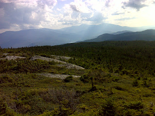
Success is also the name of the trail I used to get up to the AT today and it's the name of the very broad open mountain summit that was the high mark of today's hike. Here's some of the various views, morning moods and afternoon moods. First a stationary cloud formation over Goose Eye mountain, known as a 'lenticular wave cloud':
Next, a view back toward The Outlook, a round rock knob that the Success Trail passes - I didn't take the side trail to it since I was going on to Mt. Success:
And finally the view of the Presidentials, right of center, and the Carter Range (with Carter Dome hiding in a cloud) left of center:
The hiking continued to be easier than in the Whites, but still plenty challenging in places. I hiked south from the Success Trail intersection and stopped in at the Gentian Pond Shelter after following a recent reroute that's not on my official current ATC map nor described correctly in the ATC New Hampshire guidebook (but the new AMC guidebook and map have it right). There's a great view from this Shelter - very welcoming place beside the pretty pond:
Crossing the inlet stream to Gentian Pond was a challenge - beavers have been busy (you can see their lodge in the distance at the far end of the pond in the photo above). Then it was on up past Moss Pond and on to my turn-around point ...
... or was it all a dream? Shown up top is Dream Lake - in a very different mood from the way it looked yesterday, all brooding and shrouded in fog. Today the picture-postcard-perfect view of Mt. Madison, framed by the lake, was in full evidence. The wind was nearly calm. The air was soft and warm. The woods were hushed - not a sound, not even an overhead jet. It was truly a dream moment. I sat there and enjoyed that view and drank the can of Dr. Pepper I always bring along to 'celebrate' reaching my turn-around point. How I wish I could have lingered longer!
But there was business to be accomplished: the steep north side of Mt. Success - more than 1000 feet of climbing - was the major challenge on the way back. Seldom were there difficult footing choices, but it was just a long slog up and up some more. Of course the reward for Success was the chance to revisit those panoramic 360 degree views from the summit.
In all, it was 11 hours of hiking, four miles of side trail that 'doesn't count' and 5.1 miles of AT (that's 10.2 when covered in both directions). I'd call today a Success.
-----------------------------------------------
Here's the map of today's hike, with more photos available by clicking the link:
AT Day 191 - Mt. Success at EveryTrail
EveryTrail - Find the best hikes in California and beyond


No comments:
Post a Comment