Monday, May 7, 2012

Flatsylvania

Not in Kansas anymore? Couldn't tell it from today's trail. (Today being Sunday, April 29th)

Nine miles of trail, to be exact, extending from Little Gap northward not quite to the Leroy Smith Shelter.

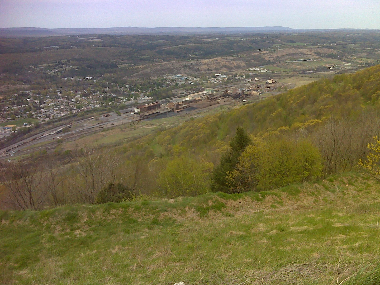
Yes, the climb out of Little Gap is steep and rocky.  You cross about a mile of intermittent rocks at the outset.  But then you hit the flats.  There's one side trail to the view shown above (view of the flat lowlands) but otherwise you're in the 'green tunnel', and most of the time you can't tell you're on a ridge.

So for the next eight miles, you might as well be in Kansas.  I've been in Kansas.  It's no flatter than this section of trail.  Pennsylvania is flat.  What's more, there were no rocks to speak of - just a few little patches.  So it was not only flat, it was smooth: Flatsylvania at its finest.

And that leaves little else to say.  It was a beautiful cool day with wall-to-wall sunshine, as you can see from the photo.  The notable highlights along the trail were few and far between - just a few trail intersections and campsites.  Oh ... and this little landmark - the 'tree of many faces':


It left me with a smile, hope it did the same for you.
----------------------------------------------------

Here's a map showing the course of today's hike.  The link in the title takes you to more photos:

AT Day 109 - the Blue Mountain Flats at EveryTrail
EveryTrail - Find the best Hiking near Allentown, Pennsylvania

Sunday, May 6, 2012

Beauty from destruction


Today (Saturday April 28th) I hiked the section of trail that has been partially relocated, between Little Gap and Lehigh Gap, to avoid the ongoing EPA Superfund restoration work.  This section of Blue Mountain got the worst of the pollution from Palmerton's zinc smelting plant, the sprawling conglomerate of buildings that sulks like a disembodied ghost in the valley below as you pass.

But the Superfund work is paying dividends.  The ridge is recovering.  And there are some starkly beautiful scenes that result.  It's almost a shame to contemplate that eventually this area will just revert to the same old boring green-tunnel woods-walking that the AT has in abundant surplus.


There was, of course, the famous rock scramble up over the bedrock spine where the Lehigh River has cut its path.  It was an invigorating challenge, more fun to climb than to descend.  And it provided some great views.  Today's walk is more about these beautiful views than anything else.


The Rocksylvania report:  Of course the climb shown above was largely over big, untamed rock.  But once you pass the upper junction with the blue blazed Winter Trail (when you reach the ridge top above  Lehigh Gap) the relocation drops down to some very mellow side-hill walking on old road grades, now green with grass.  The shot below shows Palmerton in the background.  (Formerly, I'm told, the trail followed the ridge over another mellow old road bed.)


Either way, there are no more nasty rocks until you approach the Power Line clearing about a mile south of Little Gap.  Then that temporary relocation along the Game Lands boundary from the power lines to Little Gap is frequently quite rocky.  But who knows how long this bit of trail will last - only until the patch of ridge currently under restoration is finished, I suspect.  So this report may become obsolete within a few years - or less.

As you can see, the weather cooperated nicely today.  It was a short day of hiking for me, capped off with a return to my nephew's house in nearby Slatington (just a two mile walk from the trail at Lehigh Gap where, SHAMEFULLY, the AT does not provide a simple connecting walkway - down from the Lehigh River bridge - to the 165 mile long D&L rail trail), for some fellowship with family and a nice AYCE dinner at Valley Pizza in Walnutport.  What a wonderful, fulfilling day!

-----------------------------------------------------------------

Below is the track - the route I took - for today's hike.  Near the left end (by Lehigh Gap) you'll see where I took my first serious wrong turn in 108 days of hiking.  A double blaze marking a turn coming down off the rocks was vandalized - overpainted brown - where the trail turns right, dropping over rocks and a more obviously visible and well-used trail goes straight.  This trail ends up in the same place, at the AT trailhead parking lot, but it is *not* the AT, so I had to backtrack - I'm a purist and want to "Pass every white blaze" - twice, in fact.  The photos that are available through the link below show where the other end of that wrong trail, which is marked with red arrows, comes out at the parking lot. AT Day 108 - the EPA Superfund site at EveryTrail
EveryTrail - Find the best Hiking near Allentown, Pennsylvania

Saturday, May 5, 2012

FIrst thru-hiker sighting


This is 'Samus', formerly (before Mt. Rogers) know as 'Silent Sam', whom I met today (Friday, April 27th) at the Bake Oven Knob shelter.  Samus was number 7 to register this year at Harpers Ferry, and he says he's passed two of those since.  But he's the first thru-hiker I've been able to identify as such since flipping north to PA.  Yay!  He left Springer Feb 28th and hopes to hit Katahdin in mid-June.  Good luck, 'Samus'!

For the full report from today, time restrictions force me to once again copy and paste from my personal journal, with hopes I'll be able to insert photos.  In any case all 31 selected photos taken today appear on my Every Trail link.

***********From my personal journal**************

Lehigh Gap parking area.  There I got ready for hiking; and I was on the trail at about 7AM but the parking lot was not making me feel comfortable.  There was only one car there and it was the same one I had seen when I scouted the lot after midnight (despite the sign saying the area is closed overnight).  And there was a creepy looking guy sitting in the car, hood of a sweatshirt over his head, just sitting – didn’t do much of anything.  As I started hiking, I quickly came into view of the highway and bridge over the Lehigh River below and saw a gravel space at the intersection on the east end of the bridge.  So I aborted my hike, returned to my vehicle and moved it there.  But then I got uncomfortable with that lot because there were two mailboxes beside the road and a walkway up from an adjacent house, and the only vehicles parked there seemed to be associated with the house.  Still I did a short out and back both ways from there, first back up to the lot where the creepy guy was still sitting in his car, then the other way across the bridge where I found a small gravel parking area that looked perfect, right where the AT starts the climb up the south face of the gap and adjacent but distinctly separate from a private driveway.  So I returned to my steel tent and moved it there.

Finally it was after 8AM when I started up the hill southbound.  I climbed to Outerbridge Shelter, a very rustic old one, built in the 1930’s, the front of which is literally on the trail.  I signed the register and moved on up the mountain, making various stops for clothing adjustments as it was a windy day with cold air moving in.  On the warm sunny wind-shadow side of the mountain I was warm, but needed all my layers and my hood once I got to the exposed top where the vegetation is recovering from the effects of the Palmerton zinc smelting operations.  The smelters continued to operate even as all the vegetation on the surrounding slopes and ridges completely died off down to bare rock and soil.  Now the recovering ridge I crossed today is remarkably pretty with clumps of trees returning but still many open vistas where only low shrubs including tons of blueberry bushes and mountain laurel are thriving.


I took my time through this couple miles of very different, very pretty ridge top both to enjoy the views and because the trail was fairly rocky.  Eventually I was back in the woods and walked a more than one mile long arrow-straight section from a county line monument, along the boundary to near Ashfield Road.  There I met Laurie, Husband and Elf for the third day in a row.  They were taking a rest under a tree beside the Road.  We had a nice chat again and I took a photo and Laurie, who seems a shutter bug, took lots of them.


Beyond Ashfield Road the serious big rock hit me for the first time – a fairly short intense section through a power line clearing.  Then it let up partially for a while.  In this section I found a rock right on the trail with the characteristic quartz striations running like lines through dark rock – today’s hike seemed the epicenter of this distinctive rock type, and the particular specimen I found had a very good natural AT logo in it.  Best of all the rock was of manageable size – less than ten pounds.  I stowed it and marked the waypoint, so I could pick it up and carry it back on the way ‘home’ – about 4.5 miles of carrying that rock.

On I went through more semi-rocky trail, then a long very rocky stretch, 0.4 miles, through outcrops with no views.  Another break from rock was fairly short and included the section where Bake Oven Knob shelter is located.  I stopped in and took a photo and signed the register as usual.  As I was sitting at the picnic table with the register a hiker came in and sat down and dug a snack out of his pack.  “You’re Seeks It?” he asked as he saw me sign the register.  He’d seen my entries farther south.  We got to chatting and I learned that he is a thru-hiker – the first I’ve encountered since starting my leg north.  ‘Samus’ formerly ‘Silent Sam’ (he changed trail names in the Grayson Highlands area) started in Springer on February 28th.  That means I should have encountered him somewhere along the trail down south, but apparently we missed each other.  He said he was the seventh to register at Harpers Ferry, and now the fifth on the trail, as he had passed two of them.  I had been noting register entries from two thru-hikers – T-Bone and Tolstoy.  He knew of Tolstoy, but T-Bone (came thru here March 15th) was too far ahead.

I got Samus’ photo and wished him well.  From there I made the tough approach to Bake Oven Knob from the north over plenty of big gnarly rock.  The summit was populated by five partying guys, very high and talkative, and a separate contingent of two quiet girls, all of whom who were up there from the parking lot.  I chatted with the one most vocal of the guys while taking photos of the excellent views from the top, then headed down the extremely heavily used half mile of quite easy trail to the big parking lot that was my turn-around point.  That side has only a little rock scrambling just before the summit.  I had taken my time all day not only to negotiate the rocks and soak in the experience but to be sure my neck and shoulder problems remained in check.  And I was successful in that.  I turned around at 2PM after six hours on the trail (seven if you count the aborted start and the back-and-forth hike from the second parking place). But it took me only until 6:15PM to get back to my third and final parking place.  It continued to be a windy, chilly day but the midday overcast was giving way to more sun as I descended back to Outerbridge Shelter.  There I found about 5 people, some just arriving.  And one asked if I was ‘Seeks It’.  He was very coy about explaining how he knew my name, finally revealing that my brother was waiting for me at the parking lot.  But when I got there Jim had left, so I hurriedly did the minimum wrap-up work for the hike, didn’t change clothes, and headed down to my nephew’s house, barely two miles away.

****************End-o-Journal entry*************

Here's my walk plotted on a map and a link  to the 31 photos, as promised.
 
AT Day 107 - Bake Oven Knob at EveryTrail
EveryTrail - Find the best Hiking in Pennsylvania

Friday, May 4, 2012

On the Knife Edge


The weather today (Thursday April 26th) cooperated just enough.  Rain had been forecast, then retracted from the forecast.  It ended up cloudy, chilly, raw, breezy, and virtually rain-free.  So it was not a bad day for visiting the Appalachian Trail.

I covered the trail between Allentown Shelter and Bake Oven Knob Road.  It should be called Easy Bake Oven, because the trail from there south to just before Bear Rocks (which are bare rocks) is ridiculously easy woods road - flat, level, wide, smooth.  Same goes for the section from Allentown Shelter to the power line crossing north of PA 309 - plain-out easy walking.

This stood in sharp contrast to that middle section.  As soon as you pass the power line and plunge back into the woods northbound there's 0.15 miles of big rocks to negotiate.  Then it gets easier for a while and then 0.2 miles before you reach Knife Edge the big stuff with tough footing returns and lasts for a total of 0.7 miles.

The centerpiece, of course, is Knife Edge itself, which is a short traverse of the rocky ridge line.  Frankly, I've walked sharper knife-edged ridges on the AT, and definitely longer stretches of high exposed rock (Firescald Knob comes to mind), but the views were nice when you stood still and the rock challenging when you were moving forward.

It's always fun to traverse a section like this the second time - when you know what's coming.  You can really savor it.  Yes, you savor it the first time through also, with that sort of "bring it on" adrenaline mentality - you're savoring the surprises.  On the way back, you 'taste' it more, rub it between your fingers, see it with wider vision, and let it sing.  You use your senses more and your endocrine system less.

Quickly after Bear Rocks the thrill ride ends.  Rocksylvania becomes Flatsylvania.  Nowhere, in any of the Appalachian Trail that I've covered from here to Springer, is there so much truly easy trail.  As I posted more than a week ago:  Rocksylvania gets all the press, Flatsylvania not so much - and it should.

I've yet to finish Pennsylvania, so the jury is still out, but the contrast of ankle-wrenching boot-killing rock and pansy-ass flats is what stands out in my mind so far.  What's missing, almost entirely, are the climbs.  In some strange perverted way I miss the climbs.  I can see the northern New England peaks eying me with a devilish grin and a beckoning finger - "Come play with us, dear hiker.  We'll show you some climbs."  And I'm sure when I'm there I'll be longing for good old Pennsylvania.  So I guess I better enjoy it while I'm here.


-------------------------------------------------------- 

Here's the knife-straight route I walked today, and a link to more photos:

 
AT Day 106 - Knife Edge at EveryTrail
EveryTrail - Find the best Hiking in Pennsylvania

Thursday, May 3, 2012

Pennsylvania Rocks!

Yep, they've finally hit - or should I say I finally hit them today (Wednesday, April 25th).  Two kinds of rocky trail dominate the 4.6 mile section from 0.06 miles south of Dan's Pulpit to Allentown Shelter where I turned around and headed back over it all for a second time.  (I intended to go farther and it wasn't entirely the rocks that slowed me down today - nagging neck and shoulder pain helped.  But we'll set that story aside and hope I can adapt/adjust.)

One kind of rock is the honking-big stuff with bottomless pits in between where it's rock hopping on uneven surfaces.  At left is an extreme example from just north of Dan's Pulpit, where the AT chooses to take you straight up over this rock pile.

The other kind is concentrated small rock, often on level ground, but with rocks so abundant that there's little or no smooth footing to be found.  Frankly, I'm quite sure that this sort of trail could be cleared of all its rocks - if there were enough dedicated labor available.

Both kinds of rocks slowed me down.  And in this 4.6 miles of trail I measured 3/4 mile of the big stuff, broken into nine sections of no more than 0.1 mile each, and a half mile of the small stuff, mostly concentrated on either side of the side trail to Dan's Spring.

That still identifies the large majority of this section as being not difficult.  But if you measured time spent rather than distance traveled, the rocky sections would appear to have a more significant impact (on the hiker's attention and energy as well as on their schedule).

Note also that the entire ascent from Hawk Mountain Road until you get close to Dan's Pulpit is easy trail (except for the steepness of the old woods road walk as it climbs side-slope up the upper flanks of the mountain.)

So them's the facts - the hard numbers.  But beyond the numbers is the human response.  For me - at least today - the impression left behind is dominated by those rocks.  Oh, those Pennsylvania Rocks!  They feel relentless.  They beat down the psyche.  The fact that the rocky sections are intermittent only gives them more impact - the smooth interludes put you to sleep, so to speak, so the next onslaught of rock comes as a 'rude awakening'.  And after too many 'rude awakenings' just about anybody would begin to get irritated.

There's an argument that says you need to go through rocks if you want to get to the rock outcrops where the good views come.  It's a valid point.  And there were two nice vista points and a monument along the ridge here.  Besides Dan's Pulpit, view shown below, there's Balanced Rock.  Both offer great views of The Pinnacle and surrounding farmland.  And today was a pretty day to take in the views.


Then there was an extra-curricular rock scramble to get to this nice springtime view of the Tri-County Corner monument, which also marks the point where trail maintenance changes hands from the Blue Mountain Eagle Climbing Club to the Allentown Hiking Club.


Finally, near the end of today's hiking, I had a pleasant surprise - I ran into ATC Information Services Manager and Facebook friend Laurie Potteiger, out for a section hike with her husband Dick ('Mountain Laurel and Hardy') and friend 'Elf'.


Laurie had posted on my page that she would be hiking in PA sometime soon, so meeting her was not entirely unexpected; but it was a wonderful way to end a difficult day.  They were the first people I had met on the trail all day.  And they're working north too, so we may cross paths again in coming days.  I very much look forward to that.

---------------------------------------------------

Below is a map showing today's route and a link to more photos.

AT Day 105 - Dans Pulpit at EveryTrail
EveryTrail - Find the best Hiking near Allentown, Pennsylvania

Wednesday, May 2, 2012

Pinnacle and Pulpit

 
Billed as the best view from the AT in all of Pennsylvania - this was my view today (Tuesday April 24th) looking East from the Pinnacle.  You can see the radio towers in front of Lehigh Gap and then on to where Blue Mountain ends at the very threshold of New Jersey.  It was all it was billed to be.  Yet the Pinnacle isn't all that high, and doesn't look terribly imposing in this early morning view of it from Hawk Mountain Road:
I actually preferred the simple flat rock setting that the Pulpit gave me, complete with trees appropriate for artistically framing the view:
But both viewpoints, coming on this day of excellent visibility, were pleasures not to be taken lightly.  I soaked in these two vistas on both passes today.


The hike:  Started the day visiting the quaint little six-bunk Eckville Shelter, an 'outbuilding' behind a house that serves as the caretaker's cottage.  The 'side trail' to this shelter is actually just Hawk Mountain Road itself.  Then I began the hike in earnest.

After rolling up and down through the woods for less than half a mile, the trail joins the Game Lands Service Road and follows one branch of that for more than four miles up to what was clearly once a parking area.  That was all super-easy walking.  From there it's just a quarter mile amble to The Pinnacle.  Between the Pinnacle and the Pulpit the trail is on its own, and there are one or two gnarly rock scrambles, but these are very short.  Overall, 'Rocksylvania' has yet to live up to its reputation.

From the Pulpit the trail drops down through big rocks, but trail builders have put in steps through most of this tenth mile section.  Then it takes up an old road and follows it all the way to Windsor Furnace, my turn-around point - again easy hiking.  So overall, I'd say less than a quarter mile of today's 9+ miles of trail can legitimately make claim to being difficult rock-walking.

The people:  I met three on the trail, one a clean cut gentleman out for a day hike.  The other two are a story:  I first met them as they were coming from Eckville Shelter and I was headed to it.  I asked them if the road was actually the 'approach trail'.  The older and taller of the two did the talking.  Yes, the road even has a blue blaze or two along it.  I told them about the other shelter that has a caretaker, and they younger quickly pulled out a page from a guidebook and confirmed its location.  This one seemed to be a boy going through puberty - perhaps the older one's son.

Next I caught up with and passed them on the way up to The Pinnacle and we chatted some more.  The taller one tried to keep up - clearly eager to chat, and enjoyable company for a few minutes.

Finally we met going opposite directions near The Pulpit  as I was on my return leg.  There we took the time to have some in-depth conversation, and I got the basics of their fascinating story.

They call themselves the 'Transgender Couple', and they're married.  We're talking here about  a  man marrying a woman, both of whom are transgender.  I wonder what the Fundamentalist "Marriage must be exclusively between a man and a woman" set would say about this.  No, actually I don't wonder at all.  I'd rather not waste my time.

Besides facing the burden of their sex change operations, this couple will be dealing with their age difference.  Brandon will turn 22 soon, and Hailey Jo (the more talkative by far) is 37.  She claimed to be having an 'off day' with her voice, and it indeed sounded purely male to me.  I had assumed she was male until this third encounter.  I'm a hetero guy who responds to feminine cues.  I got a few from Hailey Jo, but there were more male cues than female.  I have to believe that this Transgender thing is a long, tough road.  And Hailey Jo, very open to discuss her situation, confirmed that her 35 years of male programming were not going to go away quickly.

This pair is planning to do a long section hike - Delaware Water Gap to Springer Mountain.  They were wearing big packs and also carrying duffel bags in their hands.  I'll bet they find a way to lose some of that weight before much longer.  But they aren't attempting long daily distances - just from one shelter to the next each day.  I sensed that they felt free here on the trail, and in no hurry. 

Transgender couples who are married and *both* transgender are a rarity.  It was an unexpected delight to meet and talk with these two down-to-earth people in the entirely unpretentious setting of the Appalachian Trail.  This is a place where such social and lifestyle considerations are secondary to the fundamentals of daily life.  If only the 'real world' out there were more like the Trail.  Civilization (technology) makes us so pampered and coddled that we forget what's important, and focus on trivial differences between us.  We have too much idle time to form pompous opinions and gaggle on about them uselessly.  This is yet another reason why the Trail makes me happy - I seek fellowship with what's *really* real.  I keep coming back to that Thoreau quote:

"I went to the woods to ... front only the essential facts of life, and [to]see if I could not learn what it had to teach ..."

-----------------------------------------------------

Below is the map of today's hike.  Yes, there's a blue-blazed short cut trail that bypasses that long diversion to the Pinnacle, but I'm committed to pass every white blaze twice, so I did it the long way.  Click on the title line to the map to get a look at more photos.


AT Day 104 - The Pinnacle at EveryTrail
EveryTrail - Find the best Hiking near Allentown, Pennsylvania

Tuesday, May 1, 2012

Memories of spring

Ah, fickle spring.  One day she's your friend, the next day she's disappeared, leaving shivering flowers and hikers behind.

Last night we had an all night downpour--actually a welcome drought-buster all over the northeast - 2.5 inches as measured in the little plastic raingauge at the Eckville Shelter.  With it the temperature dropped into the upper 30's (F) and the north winds came howling.  There was heavy snow in the mountains ...

Wait ... I'm hiking in the mountains.

I got lucky.  I've been reading reports of snow and ice on the trail down south where the elevations are much higher.  Western PA got half a foot.  But the mountains I'm hiking here in eastern PA are no higher than 1700 feet, and weren't even close to getting snow.  To repeat, I got lucky.

Lucky, also, to be able  to wait out the nasty weather.  Finally I got back on the trail a little before noon today (Monday April 23rd) to find this forlorn little wild azalea bravely putting on its spring display, as if to say to the passing hiker "don't worry my friend.  Spring may have gone into hiding for a little while, but she'll be back."

Words of comfort don't keep you warm, though.  I wore some of my winter layers.  Again, I'm VERY lucky to be able to make gear choices freely every day.  I've been reading about hikers down south who had already sent home their winter gear, among them the Rainwater family, whom I met when they were just a week or so out of Springer.  They are OK, but had to abort hiking plans and hunker down in a shelter until the worst of the storm was over.

Here, my half-day hike took me from Port Clinton down to the Windsor Furnace Shelter (where three section hikers were unsuccessfully trying to get a fire going) and back again.  The only other person I saw on the trail today was a trail runner who whisked past me saying "Beautiful day!" to which I replied optimistically "Yeah, nice and cool."  The reality (for me) was a low hanging overcast with more showers passing through in the afternoon after a brief midday dry spell.

Still, it was a nice hike.  I started out by heading out of town along the Schuylkill, following a pipeline right of way:


Then passing under PA 61 as it crossed the river:


The climb up out of the river valley took me past the more well-reported of the two fires that struck the trail a couple of weeks ago.  See my report from last Monday for a look at the other fire in Halifax Township east of Duncannon.

Up on the ridge of Blue Mountain there were a couple of nice vista points before you drop down and pass a pair of springs named 'Pocahontas' and 'Minnehaha'.

The Windsor Furnace area features a short walk on gravel service roads past a small patch of mowed grass.  The only signs I saw of the old furnace were ... well ... signs (saying that it was there in the last half of the 1700's).

Rocksylvania update:  Today's five+ miles of trail featured a couple of steep climbs where the rocks were helpful, some rock-free pleasant walking, plenty of places where the rocks were annoying but didn't impede progress, an unusual section of flat bedrock walking (at left), and finally just 0.1 miles of intermittently difficult rock hopping.

Back home in the evening I enjoyed a rare meal in a restaurant - All you can eat.  I wouldn't mention it if the food wasn't excellent.  And it's actually visible from the Appalachian Trail (via 10x telephoto lens):

According to the forecast, spring is going to be slow in returning.  Tomorrow looks chilly again.  But I'll be there, dear spring, just like the little Azalea, ever trusting that you will come back to us.

-----------------------------------------------------

Here's a map and link to more photos:

AT Day 103 - Port Clinton fire site at EveryTrail
EveryTrail - Find the best Hiking in Pennsylvania