The arch shown above is the best free standing sea arch on the Big Island, yet there's no trail here, no signs, no markers, no name, as far as I know. It's so remote that you have to hike three miles over the rugged 1859 lava field to get here from either the north or the south. Even people who pass by here often miss seeing the arch. This a future part of the Ala Kahakai National Historic Trail--hike number One for this report. Someday this arch will be famous, but for now, it's a secret gem.
Hike Two was along a straight, little used Jeep Track that runs about 8 miles through Upper Waiakea Forest Reserve between Saddle Road and Stainback Highway at about the 4300 foot elevation. It's called simply 'Tree Planting Road'. Locals know about it--especially hunters. I found it by just stopping in the right place to take a look at the track that shows up on the satellite view. It was a cloudy damp day with the remnants of Hurricane Lane still plaguing the island.
Hike Three took me up to the cool flanks of Mauna Kea at 9000 feet and about a mile off the summit access road. Another 1000 feet up and there's no vegetation, but here the grasses and mamane trees are making a stark statement. The same misty day. Mauna Kea Access road was still closed by washouts.
Hike Four took me inland across the 1859 Lava Flow, on the Ala Loa - the King's Road, a 32-mile 19th century horse/mule commerce route between Kailua Kona and the harbor at Kawaihae. Almost nobody hikes this part of the old trail. These marker cairns were carefully placed every 25 feet or so 150 years ago. Note the trail winding away slightly to the right before disappearing over the horizon.
Finally Hike Five is my favorite, and this is my third visit, second this trip. It has amazing diversity, and just about the right hiking temperature, being just below 6000 feet elevation on the upper slopes of the windward side of the Saddle. Last time I hiked the Pu'u 'O'o Trail it rained the whole time. Today there was just a glorious coating of dew on everything.
Other sights along the Pu'u 'O'o Trail:
 |
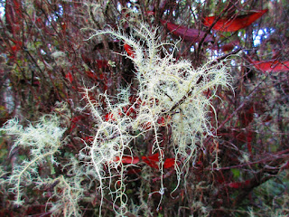
| Lichen, perked up by all the recent rain |
 |
| Berries in a quiet savanna meadow |
 |
| A little pond, usually just a dry depression, more lichen, and more peaceful meadow |
 |
| Yet another variety of lichen, this one deep in a forest understory |
 |
| Natural art of the forest over-story |
 |
| A shallow cave, collapsed lava tube |
And Hike One also featured a variety of great sights:
 |
| A hike-through natural lava arch with a low ceiling and killer view of Kiholo Bay |
 |
| Another look at Kiholo Bay. This is what's left of a massive fish pond built by Kamehameha I and destroyed by the 1859 lava flow. |
 |
| Wow! Rainbow lava. |
 |
| Keawaiki Bay and Beach |
 |
| Two more remote, seldom seen sea arches side by side. |
Here are the GPS Tracks for these remarkable hikes:
 |
| Hikes One and Four. I made a loop out of them. |
 |
| Hike two with a false start down another interesting jeep track |
 |
| Hike Three, based at the Mauna Kea Visitor Center, which was closed. |
 |
| And finally the Pu'u 'O'o Trail redux, hike five. |
What's next. Whatever it is, chances are there will be some stunning sights.


No comments:
Post a Comment