Tuesday, October 1, 2019

Tracing century-old remants of the Lincoln Highway across Nebraska on foot, Part Two

This piece of the original Lincoln Highway was paved in 1915, and hasn't changed since.  It's now closed to vehicles, but not to hikers.  See the full story below.

Continuing from the last report, my Colorado or Bust, Day 88 hike brought me from Chapman to the relatively big city of Grand Island, population 60,000.


Here they've preserved a few hundred yards of a concrete segment of the Lincoln Highway built in 1915.  It was part of a mile of concrete, one of the first "seedling miles" constructed to show the promise that paved highway could offer compared to the rutted, muddy dirt roads of the time.  The dream was to pave the entire Lincoln Highway, and these 'Seedling Miles' were meant to inspire the locals to get behind the effort, to raise funds for more paving and to get it done.  In retrospect, I suppose it worked, eh?


The following day, Day 89, I moved on from Grand Island to Wood River, where they have a well-preserved main street block with late 19th century buildings in the typical western plains style.


Out in the country between towns, I was treated to a unique memorial and one of my classic photo subjects, a specimen tree - this one a Cottonwood:


Day 90 took me from Wood River to Gibbon via the intermediate town of Shelton, which styles itself as the Lincoln Highway Capital of Nebraska.


There was more wide open Nebraska scenery, too, of course.


I call that photo 'Access to Corn'.  If you're hiking out in the open like this, mile after mile, and nature calls … well … access to ten-foot-tall corn becomes a precious thing.

Now, on Days 91 and 92 I passed through Kearney, starting in Gibbon, and ending in Elm Creek, Nebraska.


Built in 1848, Fort Kearney is the outpost of western civilization that tied all of the old transcontinental trails together.  The present town of Kearney has a 16 mile hiking/biking trail system that connects the Fort, on the south side of the Platte River, with downtown on the north, with the University of Nebraska Kearney campus, and with the Kearney Canal coming in on the northwest side of town.  I didn't hike all of this trail, but the three miles of it along the Canal provided a fine change of pace from noisy traffic and trains.


That turkey was the mama.  She had 8 or 9 youngsters who were browsing on the other side of the canal, right of the photo.  When I passed, the young-uns scurried into the deep undergrowth, then after I passed Mama came out calling for them.

In downtown Kearney, there were birds of a different feather - a congregation of religious pigeons.


Day 93 took me from Elm Creek to the neat and friendly town of Overton.


Here, in Overton, they have preserved an old concrete bridge along the original Lincoln Highway, and the boy scouts have refurbished and protected one of the original highway concrete markers, likely in its original location, now a grassy strip of parkland.


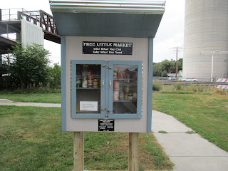
The 600 people of Overton seem to hold dear and honor one another and their history, to a degree I've seldom seen elsewhere.  Witness this well-stocked free food pantry in the roadside park near the pedestrian rail overpass (background), and their first-rate new Veteran's memorial on the east side of town.


The Lincoln Highway goes ever on.  More to come in my next report.


Tracing century-old remants of the Lincoln Highway across Nebraska on foot, Part One

An original Lincoln Highway concrete marker in its original place and original condition, standing in Duncan, Nebraska.  In the background, the grassy tree-lined 'boulevard' is the original course of the highway.  The trees were planted in 1913, upon the dedication of the highway.

Hiking to "Colorado or Bust", via the Lincoln Highway across Nebraska means hiking the comfortably wide shoulder of US 30 most of the time.  But I'm finding little remnants of the original Lincoln Highway such as the grassy tree-lined boulevard in Duncan, Nebraska, shown above and here:


The original hackberry trees, such as the one with the Lincoln highway banner, were planted in 1913 to provide shade for the travelers as they passed through town.  Some of them have died and were replaced.  There are plans to plant more replacements.

Elsewhere a 1.2 mile preserved section of the original highway features this original Pony Truss bridge over Prairie Creek that was already in place when the Lincoln Highway was dedicated in 1913.  You can still drive across it today, as long as your vehicle weighs less than three tons.


Okay, that's a teaser -- just a few of the highlights.   Let's put the rest in chronological order:

Day 82:  I hiked from Schuyler to Columbus.


There was a Mormon National Historic Trail marker in Schuyler--first one I had seen.


Columbus is a much bigger town, and calls itself the city of power and progress.  The Loup River Power Canal, shown behind the sign, brings water through a hydroelectric plant in town.


US 30 crosses the Loup River in Columbus and crosses over the town's bike trail.  Columbus also has a fancy bridge over the Union Pacific Railroad tracks, which have been in continuous operation since 1866 here.  The two bridges come in quick succession within half a mile.


Day 83, hiking from Columbus to Duncan, was when I passed the tree-lined, no longer drivable piece of highway shown above.


Day 84:  Halfway through the hike between Duncan and Silver Creek is where the old bridge over Prairie Creek, shown above, can be found.


On Day 85 I hiked from Silver Creek to Clarks.


In Clarks their brick main street is the original route of the Lincoln Highway.  They honor it with a mural and lots of telephone poles painted with the red, white, and blue highway markers, just the way it was done a hundred years ago.


I got to hike another two mile stretch of the old original highway today.  Most of it is just corn fields now.


Day 86 took me from Clarks to the town originally called Lone Tree, Nebraska.  Wish they'd kept that name.  The new name just doesn't evoke the same pioneer spirit.


Finally, on Day 87, I did the dead-straight, dead-flat walk from Central City to Chapman.


Through Chapman a part of the original Lincoln Highway is still in use; and somebody had spruced up one of the 3000 original concrete highway markers and transplanted it to their yard.


The other distinction of this day was that I could see the two towns' towering grain silos, ten miles apart, straight ahead and behind me the entire hike.  The view below is a zoom shot of the Chapman silo, eight miles distant.


More highway walking fun in the next post, stay tuned.

Wednesday, September 18, 2019

Onward into Nebraska, hiking half a dozen historic trails in one


Colorado or Bust, days 75 through 81:

It's US Highway 30.  It's the Overland Trail, a name older but less famous than the Oregon Trail, which follows substantially the same route across Nebraska.  The Oregon Trail was fading from memory until it was given new life by Ezra Meeker's 1906 re-enactment of his 1852 journey as a young family man seeking land to call his own.  His re-enactment gained great press attention and was the subject of a popular memoir he wrote about the trip.  In Nebraska, the same route was followed by Brigham Young and his Mormon followers in their migration to Utah.  And it's the same route used by the '49er gold seekers headed to California.

Between 1834 and 1867 an estimated 400,000 cross-country travelers followed the route along the Platte River.  To be sure, few of them walked the whole way.  This was no recreational trail.  An estimated 10,000 to 20,000 of those who set out on the trail died before reaching their destination.

It was a trail that made history and changed history as few others have.  It is the trail that built the west.  It's hard to underestimate its impact.

Sometimes I get goosebumps as I stop to read some of these historic markers.


In 1869 the very same Platte Valley route was opened to transcontinental railroad travel, and the stream of travelers only increased.


In 1903 Dr. Horatio Nelson Jackson drove this same route in his 20 horsepower Winton motorcar.  Upon arriving in New York City, his drive was celebrated as the first coast-to-coast automobile trip.

Only ten years later, the Platte Valley route became part of the first marked transcontinental motor highway, the Lincoln Highway.


In November 1926, barely a dozen years after the Lincoln Highway was dedicated, the US Highway numbering system was approved, and the Nebraska portion along the Platte River was designated as US Highway 30.

It's still called that today.  But all those other names, with the rich layers of history they represent, are still remembered and celebrated.

And that's why I'm walking this way.  The Overland Trail, in particular, takes me directly to my destination, Fort Collins, Colorado, where the original trail follows a street still named Overland Trail that was my daily commuter route for ten years.

Much more on this as time progresses.  For now, it's time to return to US 30 in western Iowa and eastern Nebraska.

I crossed the Missouri River on the Blair Bridge, a 1991 replacement of a bridge first opened in 1928 and heavily advertised as the Lincoln Highway's latest improvement.


It was another goosebumps moment as I looked down upon the swirling currents and imagined the Lewis and Clark party working their way upstream in their simple canoes, hugging the shore to avoid the current, always seeking out those counter-currents and eddies that would ease their way north and west into the unknown reaches of Jefferson's Louisiana Purchase.


It wasn't all about the uncountable stories of the travelers who came before me.  Sometimes it was just about the here and now.


Here's the GPS Track collection for the week of hiking covered.


It's an excellent adventure, this.  Highway walking has its perks, and every small town I pass through feeds me another tasty bite of real, honest-to-goodness America.  I'm loving it.