Saturday, May 12, 2012

Friday May 4th

It rained in the morning for the 4th consecutive day. All of May! And it was foggy for the third morning. Today the rain was over by 6:30 but the fog lasted until noon. Then it got hot.

Today's bit of trail - about ten miles between Millbrook-Blairstown Road and about a mile south of Brink Road Shelter followed the ridge with lots of little ups and downs and some semi-Rocksylvaina-style rocky trail.  There was even an unexpected scramble up this cliff beside Crater Lake.  I needed to use my hands.

The best views of the day were those with lakes, now seemingly abundant along the trail (ever since we crossed Wolf Rocks, PA and entered the landscape that was carved by glaciers.  Here's Fairview Lake from a heavily used viewpoint near Blue Mountain Lakes Road.
A note about Blue Mountain Lakes Road. They have newly gated it off all the way down where it ends at Millbrook-Flatbrookville Road. I hear that there was some damage last year from Hurricane Irene, but the real reason for the closing is because of the sorry condition that govt. budget cuts have left Delaware Water Gap NRA in. The M-F Road is riddled with unrepaired potholes. This Recreation Area is huge and isolated between the mountain and the Delaware River, and nobody lives on that side of the mountain. It feels as remote and isolated as any place I passed through in Southwest Virginia, but it has a different feel - neglected, unloved.

From the rocky top of Rattlesnake Mountain you get a nice vista overlooking that wooded and wild terrain

On the trail I met two section hikers, one going north, whom I've passed multiple times in recent days.  Today we finally had a good chat.  He's 'Sun Dog' from MN, and is hiking Duncannon to Katahdin after doing Springer to Duncannon last year and getting sick.  The other is 'Kit Kat'.  She's hiking south from MA to Daleville, VA and hopes to complete the trail with further section hikes before the end of the year.

I also met two interesting critters on the trail today - a porcupine climbing a tree and this cute little guy - a Red Eft:
He's the juvenile stage of the ubiquitous Eastern (spotted) Newt. I've seen dozens of these little guys over the past few damp days. But today I finally got a good 'mug shot'.

As I said up front, at about noon the weather broke after three foggy days in a row. It got hot and humid - but also allowed for the nice views shown above. I'm unusual among hikers in that I do not mind the heat and I actually prefer humid weather to dry. I like to sweat and do it well (*grin*). Probably the same high ratio of skin surface to body weight that makes me susceptible to feeling cold also allows me to keep cool efficiently by sweating. In any case, I enjoyed the afternoon, and especially the early evening hiking when the cool returned but the humidity lingered on. All in all a very enjoyable 20 mile day, my 114th day hike of this adventure. Onward to Maine!

 ------------------------------------------

Here's my hike plotted on a map, with a link to more photos:

AT Day 114 - Kittatinny Mountain at EveryTrail
EveryTrail - Find the best Hiking in Kittatinny Valley State Park

Friday, May 11, 2012

Found it ... in abundance

When I was saying goodbye to the tight-knit foursome of thru-hikers that I met north of Newfound Gap in Smoky Mtn Park, one of them said, "Good Luck, 'Seeks It'.  I hope you find it."

It wasn't the right time, so I didn't explain to him that it's not like that.  I find a bit more of it (Fellowship with the wilderness, the intertwining my self with my essential nature) every day.  But today I found a mother-lode!
On my return trip to Sunfish Pond (Thursday May 3rd) it opened up its vistas to me. There was barely an hour of nice weather, and I was in the right place. It had been densely foggy all morning.  As I approached, the fog lifted long enough for me to explore the pond and have a little lunch, and then the east wind picked up and the fog rolled back in. But while I was there, I had the entire place to myself - surely a rarity in this popular place. Human voices ruin the wilderness experience for me - children shouting, partyers laughing ... I might as well be in the city. But today the wind was calm and the whole expanse of the pond, laid out before me like a window into heaven, sang to me with only natures songs.

If you are AT-hiking past Sunfish Pond, be sure to take the Turquoise Trail on the north end, just a tenth of a mile, to the high rock point where the third photo was taken. There is no finer viewpoint from which to take in this magical setting of pristine wilderness. I had a rock seat with backrest there to witness it all -- I felt a truly wealthy man.

The ridge walk to get there from Millbrook-Blairstown Road is one of the prettiest extended sections of ridge walking I've found, and I say that even though I could not fully see the nearly constant vistas it presented from its glacier-smoothed, rubble-swept-aside bedrock walks. There was even the Catfish Fire Tower to climb if you didn't get enough of the vistas from the rest of the walk. When you're not on exposed ridge you're walking through a delightful variety of woodlands, savanna-like glades, and grassy knobs that felt almost alpine.

And after receiving all these gifts, there was an unexpected bonus waiting for me as I took a short stroll north of Millbrook-Blairstown Rd: A rock-lined lily pond that has been adopted by beavers.  What a wonderful day!

---------------------------------------------------------

Here's my hike plotted on a map, with a link to more photos:


AT Day 113 - Sunfish Pond at EveryTrail
EveryTrail - Find the best Hiking in New Jersey

Thursday, May 10, 2012

On reaching New Jersey

Wednesday, May 2:  When I got up this morning I checked the radar and saw showers coming. The rain started soon after sunrise, so I took my time getting ready.  The rain kept getting stronger.  Soon it was 10AM and raining harder than ever.  Still the radar showed the end in sight, so I chose to wait it out.  I picked up my sewing kit and finally sewed my ATC Life Member patch onto a hat.
It was 12:30PM before I hit the trail, and it was still drizzling.  The drizzle never completely stopped all day, and the temperature only dropped - upper 50's at noon, low 50's by sunset.  And the mountains above about 1000 feet were shrouded in fog all day - what a contrast from yesterday!

Still I got to see everything that was worth seeing.  I finished up Pennsylvania with a walk across the I-80 bridge after a visit - just a few blocks of road walking - through the town of Delaware Water Gap (Deer Head Inn shown at left) and a climb back up into the fog on Mt. Minzi.

But Lookout Rock was beneath the base of the clouds, so the views were there for the taking.

Late in the afternoon I made my first serious foray into New Jersey, hiking the heavily used trail up to Sunfish Pond - about four miles from the Dunnfield Natural Area parking lot.  Fog encased me and this special body of water into a mutual cocoon.  I had the entire place to myself this early evening.  The wind calmed and the Wood Thrushes began to sing.  Even though I couldn't see all there was to see (the other side was a dim shadow), I knew that I was being granted a special gift.  I can keep this treasure of memories forever; and best of all I'll be back again tomorrow.

Pictures below are from the south end, the middle and the north end.

------------------------------------------------

Here's a map and link to more photos:

AT Day 112 - Delaware Water Gap at EveryTrail
EveryTrail - Find the best Hiking in New Jersey

Tuesday, May 8, 2012

Gettin' better by the minute

Sometimes you just have to spill the punch line up front.  Here it is:


This is the late afternoon view of the Delaware River from Mt. Minzi.  This was a day (Tuesday May 1st) that dawned cloudy and foggy with thunder and rain.  I got a late start but still hiked nearly 18 miles.  The day may have started lousy; but it just got better by the minute!

Morning found me traversing the difficult 0.2 mile stretch of rock-hopping on Wolf Rocks with the rocks still soaking wet.  My shoes slip on these kinds of rocks when they're wet.  I skinned my left shin before I went ten feet on the rock.  I slowed down, testing every step for its slip-factor.  But 0.2 miles of tough stuff at Wolf Rocks and a little patch at Lunch Rocks is all 'Rocksylvania' threw at me today.

Beyond Wolf Rocks I re-entered the dismal wilds where I ended yesterday's hike.  I don't like this section of trail because it is a woodland that is struggling.  I'm sensitive to that.  I wish I could explain it better.  There was one highlight - a remarkably effulgent oasis amid the drear.  Oasis indeed - the 'Seasonal Spring' on this otherwise barren section of broad flat ridge was gushing to overflowing.

This section has an intimidating look to the rock.  The trail is straight and flat and a jumble of jagged stones that often seems to stretch to the horizon. But here's some advice (worth what you paid for it):  you can't walk it all at once, so don't try.  Stop anticipating.  Look down at your next few steps and you find that there are more smooth, comfortable places to put your feet than you have feet!  As I said yesterday, put your mind on auto-pilot, shut down the angst and analysis, and let the 5 million years of barefoot-walking hunter-gatherer genes do their thing.  Suddenly Rocksylvania (all but the very limited big bad stuff where you *do* have to think about footing) is no big deal.

The weather began to improve.  Walking back across Wolf Rocks, I now found them dry.  And the fog had dissipated.  Now I could see the view - nothing to write home about really.  Back at Fox Gap I began the much more entertaining leg north.

It got good after Kirkridge Shelter.  I got to Lunch Rock and could see the next few miles of trail stretched out before me.  Actually, I could see the first half dozen miles of trail into New Jersey as well.  And by now the weather had turned perfect - calm, warm, just enough humidity to make the air feel soft, yet not enough to smother the views.

For me this is perfect - ideal weather for walking the wilderness.  So I took my time on the way back.  I found a secret vista with just a hint of a trail leading to it and sat there drinking in the experience with all five senses.  I dawdled at every other viewpoint.  I let the afternoon slip into evening.  I milked this day for everything it had.  So I got back 'home' at dusk, by now in a state of euphoria.  Today just kept getting better by the minute, right up to the very last.

---------------------------------------------------

Here's the plot of my route for today's hiking.  The title above the map is a link that will take you to many more photos and other trip information:

AT Day 111 - Wolf Rocks, Mt. Minzi at EveryTrail
EveryTrail - Find the best Hiking near Allentown, Pennsylvania

The two faces of Wind Gap

"I've looked at Wind from both sides now - from south and north - and still, somehow ... It's Wind's illusions I recall.  I really don't know Wind ... at all."

With apologies to Joni Mitchell, Wind Gap was somewhat of an enigma.  My scouting report said that the north side would be super rocky.  The south side was - but the north? ... not so much.  Today (Monday April 30th) I hiked 5.5 miles of trail on the south side and 4.5 on the north side.  The more rocky south side was more  fun - the north? ...not so much.  I *can* explain that ... at least in part.

The south side had vistas that gave you a look to both sides of the ridge, including this one from the pipeline clearing about halfway through today's south-side leg.

It was on the south side that I met my second, third, and fourth thru-hikers since flipping up north.  The tide is rising!  The picture below is of Iceman.  He's from Kentucky, and his parents are going to meet him at Delaware Water Gap tomorrow, so he and his trail partner 'Viking' and a new associate, 'Achilles' did a monster 33.5 miles yesterday and will do the 20+ to DWG today.  If all works out, Iceman's parents will support them so they can slack-pack through New Jersey.  Just like 'Samus' (who they were all very keen on hearing my news about), they need to reach Katahdin by mid-June.  That's 900 more miles in just a month and a half - 20 miles every single day with no zero's - a tough haul to be sure.  But these guys were lean and fit, so I give them a good shot at finishing.  And I left them with my best wishes for success.


Finally, the south side had the Leroy Smith Shelter.  Who takes photos of the inside of privies???  This one was worthy of it.  The Appalachian Mountain Club, Delaware Valley Chapter, has done itself proud with their meticulous maintenance and upkeep of this shelter.  I've seen none finer.

My return trip through this stretch of rock taught me something valuable about 'Rocksylvania'.  Once I've done the trail one way, I sometimes let my mind wander on the way back.  And voila!  The trail goes faster, not just mentally but physically.  I put my feet on auto-pilot and they negotiate the rocks more efficiently.  It's letting the millions of years of evolutionary honing of the 'animal' instinct in us take over - the barefoot hunter-gatherer- and not allowing our human hyper-active frontal lobes to override that much deeper and more finely-tuned 'operating system'.  Eyes to feet.  No conscious thought required.  Try it ... it really works.

Now ... about the north side.  The climb up is steeper and on much more neglected trail, with old stone water-bars no longer functioning, and erosion out of control.  You get up top and the trail wanders through scrubby woods with lots and lots of invasive Japanese Barberry and even more invasive Japanese stiltgrass.  The trees are forlorn, morose, stunted, none very large, as this land has not been left to go wild for more than a few decades and looks to have been abused before that.  The ridge widens out so that there is no chance of any views; and the trail just goes on and on through this (to my sensibilities) monotonous ugliness.  The prettiest scene I could extract from all this was this 'Fangorn Forest'-like stand of twisted Sassafras growing out of the Barberry thickets:


My internet friend Dave Cullen asked me to photograph campsites through this section as a favor to him and his hiking friends who are considering doing this section on up to Fox Gap. I photographed 8 campsites today, and they appear on the Every Trail site. Based on those, you do not need to accept my judgement regarding this stretch of trail. Yes, it's all woods and wilderness. Perhaps that's more the point for many of you. I'm just "telling it like I see it".  And remember - "It's Wind's illusions I recall. I really don't know Wind ... at all."

---------------------------------------------

Below is a map showing the route of today's hike.  With it is a link to more photos.  Just click the title.

AT Day 110 - Wind Gap at EveryTrail
EveryTrail - Find the best Hiking near Allentown, Pennsylvania

Monday, May 7, 2012

Flatsylvania

Not in Kansas anymore? Couldn't tell it from today's trail. (Today being Sunday, April 29th)

Nine miles of trail, to be exact, extending from Little Gap northward not quite to the Leroy Smith Shelter.

Yes, the climb out of Little Gap is steep and rocky.  You cross about a mile of intermittent rocks at the outset.  But then you hit the flats.  There's one side trail to the view shown above (view of the flat lowlands) but otherwise you're in the 'green tunnel', and most of the time you can't tell you're on a ridge.

So for the next eight miles, you might as well be in Kansas.  I've been in Kansas.  It's no flatter than this section of trail.  Pennsylvania is flat.  What's more, there were no rocks to speak of - just a few little patches.  So it was not only flat, it was smooth: Flatsylvania at its finest.

And that leaves little else to say.  It was a beautiful cool day with wall-to-wall sunshine, as you can see from the photo.  The notable highlights along the trail were few and far between - just a few trail intersections and campsites.  Oh ... and this little landmark - the 'tree of many faces':


It left me with a smile, hope it did the same for you.
----------------------------------------------------

Here's a map showing the course of today's hike.  The link in the title takes you to more photos:

AT Day 109 - the Blue Mountain Flats at EveryTrail
EveryTrail - Find the best Hiking near Allentown, Pennsylvania

Sunday, May 6, 2012

Beauty from destruction


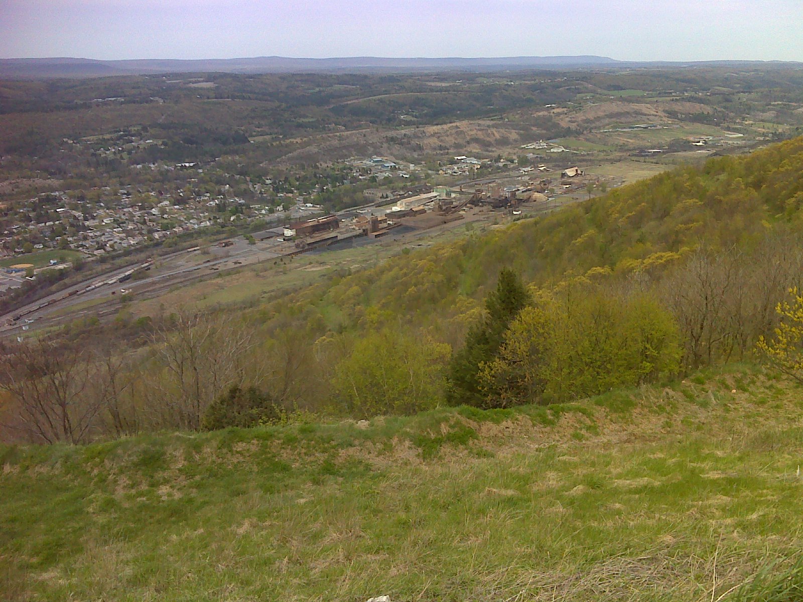
Today (Saturday April 28th) I hiked the section of trail that has been partially relocated, between Little Gap and Lehigh Gap, to avoid the ongoing EPA Superfund restoration work.  This section of Blue Mountain got the worst of the pollution from Palmerton's zinc smelting plant, the sprawling conglomerate of buildings that sulks like a disembodied ghost in the valley below as you pass.

But the Superfund work is paying dividends.  The ridge is recovering.  And there are some starkly beautiful scenes that result.  It's almost a shame to contemplate that eventually this area will just revert to the same old boring green-tunnel woods-walking that the AT has in abundant surplus.


There was, of course, the famous rock scramble up over the bedrock spine where the Lehigh River has cut its path.  It was an invigorating challenge, more fun to climb than to descend.  And it provided some great views.  Today's walk is more about these beautiful views than anything else.


The Rocksylvania report:  Of course the climb shown above was largely over big, untamed rock.  But once you pass the upper junction with the blue blazed Winter Trail (when you reach the ridge top above  Lehigh Gap) the relocation drops down to some very mellow side-hill walking on old road grades, now green with grass.  The shot below shows Palmerton in the background.  (Formerly, I'm told, the trail followed the ridge over another mellow old road bed.)


Either way, there are no more nasty rocks until you approach the Power Line clearing about a mile south of Little Gap.  Then that temporary relocation along the Game Lands boundary from the power lines to Little Gap is frequently quite rocky.  But who knows how long this bit of trail will last - only until the patch of ridge currently under restoration is finished, I suspect.  So this report may become obsolete within a few years - or less.

As you can see, the weather cooperated nicely today.  It was a short day of hiking for me, capped off with a return to my nephew's house in nearby Slatington (just a two mile walk from the trail at Lehigh Gap where, SHAMEFULLY, the AT does not provide a simple connecting walkway - down from the Lehigh River bridge - to the 165 mile long D&L rail trail), for some fellowship with family and a nice AYCE dinner at Valley Pizza in Walnutport.  What a wonderful, fulfilling day!

-----------------------------------------------------------------

Below is the track - the route I took - for today's hike.  Near the left end (by Lehigh Gap) you'll see where I took my first serious wrong turn in 108 days of hiking.  A double blaze marking a turn coming down off the rocks was vandalized - overpainted brown - where the trail turns right, dropping over rocks and a more obviously visible and well-used trail goes straight.  This trail ends up in the same place, at the AT trailhead parking lot, but it is *not* the AT, so I had to backtrack - I'm a purist and want to "Pass every white blaze" - twice, in fact.  The photos that are available through the link below show where the other end of that wrong trail, which is marked with red arrows, comes out at the parking lot. AT Day 108 - the EPA Superfund site at EveryTrail
EveryTrail - Find the best Hiking near Allentown, Pennsylvania