Friday, August 10, 2018

Dry coast and wet coast, a Sampler from Paradise

Sea turtles come ashore to rest.  They've lost all fear of humans and predators.

What I saw today.  The Shoreline Trail and Kalahuipua’a Historic Park in the Mauna Lani area of the west (dry) coast north of Kona, and Onomea Bay area of the northeast (wet) coast north of Hilo.  Two morning hikes before the skies opened up their floodgates.

Ancient cave dwelling
a few of the best of 27 different petroglyphs collected at Puako Archeological Preserve
 
Lahuipua'a Fish Pond, still productive, constantly maintained for nearly a millennium now
Shoreline Trail winds past natural areas and resort beaches
Another of the four turtles I encountered in 2 1/2 miles of shoreline trail
Beehive Ginger, Hawaii Tropical Botanical Garden, back for a second visit to my favorite place.

Stunning, almost frighteningly exotic orchid
The Lily Pond
Here's the GPS Track of my meanderings in the Mauna Lani area.


The trail fizzles out at private residences with sea walls that jut into the water on the north, but the Shoreline Trail continues south for several miles - exploration for another day.

Thursday, August 9, 2018

The Ka'umana Trail, a 1000-year-old footpath

Trail views like this only happen in paradise.
 
Hiking in the barefoot steps of the ancients today, I covered a short 1.7 mile section of one of the Big Island's four main prehistoric inland trails.  Cleared by the Polynesians and marked with large cairns whose constituent rocks now bear aged beards of lichen, these trails were shortcuts across the island's interior, likely used for commerce and access to hunting grounds and ceremonial sites.

The preserved piece of trail I hiked is at 5000 feet elevation near the Saddle Road.  It was a glorious clear day there, unlike the day I hiked the nearby Pu'u 'O'o Trail.  There were views of the ocean below (though hazy) and of the shimmering modern monuments of Mauna Kea - its telescope domes.


The trail bed is solid lava, of the smooth Pahoehoe type.  But even pahoehoe can take a variety of forms.  Here is a fine example of what's called "rope pahoehoe".


Doing this 1.7 mile route even both ways left plenty of time for further hiking and exploration today.  Next I headed up Mauna Kea, stopping along the road to snap a shot of another twisted old Mamane tree.


At the visitor center at 9200 feet I had a chance to visit half a dozen or so of just 1400 living specimens of the Critically Endangered Mauna Kea Silversword.


At one time about 40 years ago there were just a handful of known plants left in the wild.  With the feral sheep and goats now being controlled and with an active hand-pollination and breeding program, this plant is making a comeback from the very brink of extinction.

From the visitor center I took a training hike half way up to the summit of Mauna Kea and back.  Views were stunning.


On the horizon you can see a plume of smoke that I thought meant a serious new eruption event was taking place at the active volcano down on Kilauea.  But it turns out that it was from a large brush fire still burning out of control 24 hours later.

Above about 11,000 feet I saw no vegetation, not even a tiny sprig of grass or weed sheltered among the rocks.  It is said that the silversword lived up here, but today the last substantial plant I saw provided a surprising splash of color at about 10,500 feet.


Otherwise the joy of this hike came from the sense of vast expanse.  Here the trail seems headed straight for Mauna Loa.


A visit to the Mauna Kea summit at sunrise or sunset is a must when you're on the Big Island.  To get there, though, you have to have a four-wheel-drive vehicle or book a tour.  What struck me most was when I looked *away* from the sun and saw the shadow of the entire mountain creeping across the haze and cloud over the Pacific.  This view is reserved only for sunset.  The mountain's high point, the actual summit cone, is the land seen to the right of its own shadow.


The previous day I hiked the eastern tip of the island at sea level.  This is the 2.5 mile Puna Trail, part of an old government road built for horses in the 1800's.  Like most of the island, its bed is made of solid pahoehoe.


The trailhead is in an area spectacularly studded with wild orchids.


In the middle it is deep tropical rainforest, here seen as the setting for a small trail-side cave.


And at the far end it comes out at a beach and homestead of major Island landowner W.H. Shipman.  Here were waves crashing in from major Hurricane Hector, which is passing within a couple hundred miles of the island as I write this.


The rock crabs don't seem to mind the pounding waves.  In fact they seem to thrive in this battering surf.


At the Shipman homestead I had a chance to visit with another endangered endemic Hawaiian icon--the nene goose.  This fellow is one of only about 2500 birds alive today.  It was a rare honor.  This land has been kept by the Shipmans as a nene sanctuary for nearly 100 years now.


After the hike I drove through the heart of the eruption zone.  Roads into the actual lava areas are closed with the National Guard manning roadblocks, but highway 130 crosses right over the East Rift Zone where the eruption split the earth wide open.  The road is covered with steel plates over the new cracks, and there are signs warning drivers to roll up their windows and turn off vents and do not stop.


The smelly sulfurous steaming cracks leading straight to hell were fuming right beside the road.

Later I made my last stop at my favorite place in the world to check out the roaring surf at the end of the Donkey Trail at Onomea Bay, just 6 miles north of Hilo.


Hurricane Hector actually caused the wusses at Hawaii Tropical Botanical Garden to close for the day.  What were they afraid of?  The surf is probably worse in the winter.  The wind was roaring along at maybe 2 miles per hour.  The rain was steady but light.  There are worse downpours here on most normal days.  WTF HTBG? Probably just a lame excuse to take a day off.

The hurricane is supposed to bring more rain tomorrow, possibly even up on the flanks of Mauna Kea.  As usual, I'm not sure what I'll do, but whatever it is, I'll be doing it in paradise :-)

Sunday, August 5, 2018

9000 feet on Mauna Kea - Red Hill and the realm of the Mamane tree

Red Hill cinder cone, with Mauna Loa in the distance

It's called Pu'u Kale, which translates to 'Red Hill'.  It rests on the slopes of Mauna Kea, and its summit is just under 9000 feet elevation.  Today I hiked there and climbed an adjacent cinder cone with no name that I know of, so I called it 'My Hill'.

Red Hill is a sight to be seen more than a summit to bag.  'My hill' is, in my opinion, the summit to explore in person because it's not just a lot of loose barren gravel.  It is populated by some fantastic specimens of the endemic Mamane tree, a member of the pea family.  Here's the most venerable old denizen that I found.


Trees with character are one of my favorite photographic subjects.  Trees that endure the harsh, dry climate and thin rocky soil here can hardly help but develop character.  Even after they've long since passed away.


Weather had been bad for a day with what's called a Tropical Easterly Wave rolling through.  Down in Hilo it rained heavily for fifteen minutes every hour and a half for most of two days.  Even up here at 9000 feet it was cloudy and there were showers yesterday.  But today the system had moved on and the sun rose stark and bright above the cloud tops at about 7300 feet.  Here's an early morning view of another cinder cone at about 7800 feet, seen on my drive up.


After climbing 'My Hill' I stopped in at the Mauna Kea Visitor Information Center and then took a short walk to the summit of another cinder cone called Pu'u Kalepeamoa.  Great views of Mauna Loa and the Saddle area from there, and along the trail I found another example of the beauty that death bestows on the Mamane tree.


Feral goats and sheep have degraded the Mamane forests since Europeans introduced them here.  Whether they can be blamed for the demise of this particular tree is beyond knowing, but what I can do is demonstrate how these trees work to sustain a healthy ecosystem.


They can bloom profusely, and their immature seeds are the sole diet of the critically endangered ʻōʻū poʻopapale, commonly called the palila, a Hawaiian Honeycreeper that lives nowhere else in the world but on these upper slopes of Mauna Kea.  Again our friend J. G. Keulemans has provided this 1879 drawing:


Here's a track of the Red Hill/My Hill and Pu'u Kalepeamoa hike.  The color of Red Hill is clearly most intense on the north facing side, which is the view I had.


To cap off the day I headed back down to the Saddle Road and visited a tiny woodland reserve on another cinder cone that has been isolated from the surroundings by a recent lava flow.  This is Pu'u Huluhulu.


It's like a little mountain wedged perfectly into the gap between the Big Island's two giants, Mauna Loa and Mauna Kea.  It's just 6600 feet at its summit and the trees here are not the Mamane, but unfortunately I have no identification for these photogenic specimens.

View of the Mauna Kea access road and the mountain's slopes from near the summit of Pu'u Huluhulu
Looking west toward the Kona coast from the top of Pu'u Huluhulu.  The recent lava flow that surrounds this forest enclave is clearly visible below.

These were the hikes I chose today.  I generally don't make final decisions about where to go until the morning.  So watch this space to see what's next.


Saturday, August 4, 2018

Day 4, Pu'u 'O'o Trail loop, Hawaii


Today I headed up the Saddle Road from Hilo because the weather was lousy down in Hilo, with shower after shower rolling in on the trade winds.  I hoped to get above the weather by hiking at almost 6000 feet elevation on an old Cattle drive trail between a ranch up here and the southern part of the island.  The ranch and the trail are called Pu'u O'o.

A pu'u is a hill, specifically a cinder cone.  The 'o'o is an extinct Hawaiian bird whose strikingly brilliant yellow wing accent feathers were used to make ceremonial robes and capes ands staffs for the king and nobility of the native Hawaiians.  They carefully conserved the species by catching the birds live, plucking feathers, and then releasing them.  Europeans came and slaughtered them to extinction within a few decades in order to add the stuffed birds to their collections and to sell as caged birds that rarely lived a week.  I'm native European and my shame knows no bounds.


Last known sighting of the poor 'O'o bird was not far from where I hiked today, back in 1934.

Also shown in the above 1893 drawing by J. G. Keulemans is the bright red flower of the 'O'hia Lehua tree, also shown growing as a shrub amid the lava along the trail in the headline photo above.

According to Hawaiian legend, 'O'hia was a most handsome man.  He and his young lover Lehua were out strolling alone one evening.  The volcano goddess Pele herself approached 'O'hia, making advances to him, but he rejected her.  In a fit of rage Pele turned 'O'hia into a tree.  Young Lehua was reduced to tears and inconsolable, and Pele instantly regretted her act.   But she was unable to reverse it, so instead she turned Lehua into the beautiful red flower that is forever adorning her lover's branches.

The 'O'hia tree is not a threatened species.  It's everywhere in Hawaii; it's not picky about climate or soil conditions, thank goodness.

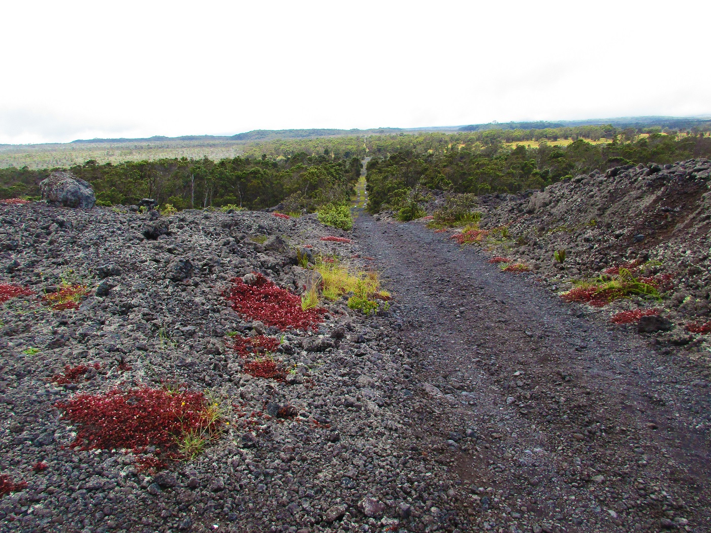
The Pu'u 'O'o trail loop that I hiked today is about 9 miles.  It follows a route through recent lava flows interspersed with Kipuka--islands of old growth forest that were spared by the lava.  One can be seen in the distance in the headline photo.  When crossing the lava, the trail is marked by big, well-built Ahu - what we call Cairns on the mainland.  One of those is also shown in the photo.

Now for the drama.  About a mile into my hike I saw one of these colorful sheep with big curving horns.


I couldn't grab my camera quick enough, and it scampered away into the trees.  Turns out that this is a European introduction, brought in by the game hunters to enhance their experience.

Not ten minutes later it began to rain.  I had been suckered into thinking I was above the rain by the benign conditions I found when I got to the trailhead.

For the next seven miles I was marching along in heavy rain and fog and mist and strong wind, huddled under my trusty Go-Lite umbrella.  When hiking in Hawaii (except perhaps on the Kona side), if you don't carry your umbrella with you then you're a certifiable Loon-ball.


When I got to this pristine cave--an old collapsed lava tube called Emesine Cave, which you have to have a permit to enter--the weather was beginning to let up, but you can get a sense of the dreary conditions.

I had finished the foot trail portion and was hiking back toward the Saddle road on a 4x4 track that was probably the more recent version of the cattle-drive route.

Finally there were a few moments of sun and I caught a glimpse of some of the majestic sights I was missing--here a look at the slopes of Mauna Kea.


Here's a look back toward the south from the same spot.


I had a chance to appreciate the odd varieties of vegetation and lichen that habitate the jagged 'A'a lava flows--don't fall while hiking around 'A'a.  You'll be cut to shreds.


Even here in this semi-cool harsh climate there were wild native orchids with amazingly delicate blooms.


The breezes quick-dried my pants as I returned to my car.  Fifteen minutes later it was pouring down rain again.

Here's my hiking route superimposed on the Google satellite image.  You can see the various types of ground cover that the trail traverses.  The green patches are the Kipuka.  The darkest black are the razor-sharp fractured 'A'a lava flows, and the gray is the smooth Pahoehoe lava.


And for context, here's a wider view of most of the island with the track located near the center.


I'll be looking for someplace dry to hike tomorrow.  Maybe Kona (the leeward, sheltered side on the west.)